Earth Science worksheet
    Topic: Global Changes Resulted From Plate Motions
    Global Changes Resulted From Plate Motions
    Base your answers to questions 1 on the drawing below and on your knowledge of Earth science. The drawing represents a swamp-forest environment that existed in North America at the base of the Acadian Mountains during the Carboniferous Period. Organism A lived in this swamp-forest.

    geologic-history, reference-tables, earth-history, evolution-of-life-forms-and-the-free-oxygen-in-the-atmosphere, standard-1-math-and-science-inquery, changing-length-of-a-shadow-based-on-the-motion-of-the-sun, standard-6-interconnectedness, models fig: esci12015-examw_g49.png

    1

    At the time represented by this drawing, the region now known as New York State was inferred to be located

    (1) at 45° S latitude

    (2) at 45° N latitude

    (3) near the equator

    (4) near the North Pole

    2

    The map below shows the current location of New York State in North America.

    geologic-history, reference-tables, dynamic-earth, global-changes-resulted-from-plate-motions, earth-history, changes-resulted-from-plates-motion, standard-1-math-and-science-inquery, changing-length-of-a-shadow-based-on-the-motion-of-the-sun, standard-6-interconnectedness, models fig: esci62016-examw_g6.png

    Approximately how many million years ago (mya) was this New York State region located at the equator?

    (1) 59 mya

    (2) 119 mya

    (3) 359 mya

    (4) 458 mya

    3

    The map below shows the present-day positions of the continents. Points A through D represent locations on Earth’s surface. The location of New York State on the North American continent is indicated.

    reference-tables, generalized-bedrock-geology-of-new-york-state, earth-history, earth-history, geologic-time-units-and-the-events, dynamic-earth, global-changes-resulted-from-plate-motions, earth-history, changes-resulted-from-plates-motion, standard-1-math-and-science-inquery, changing-length-of-a-shadow-based-on-the-motion-of-the-sun, standard-6-interconnectedness, models, standard-6-interconnectedness, patterns-of-change fig: esci62017-exampwr_g13.png

    Which letter best represents the inferred position of the New York State region on Earth at the end of the Devonian Period?

    (1) A

    (2) B

    (3) C

    (4) D

    4

    The X on the map below indicates the region where the state of Washington is located on the present-day North American continent.

    geologic-history, reference-tables, dynamic-earth, global-changes-resulted-from-plate-motions, earth-history, changes-resulted-from-plates-motion, standard-1-math-and-science-inquery, changing-length-of-a-shadow-based-on-the-motion-of-the-sun, standard-6-interconnectedness, models, standard-6-interconnectedness, patterns-of-change fig: esci62019-examw_g17.png

    During which geologic period was the region of Washington State closest to the equator?

    (1) Cretaceous

    (2) Triassic

    (3) Mississippian

    (4) Ordovician

    5

    At the end of which geologic time period were the continents of South America and Africa joined together and entirely located south of the equator?

    (1) Paleogene Period

    (2) Jurassic Period

    (3) Permian Period

    (4) Devonian Period

    6

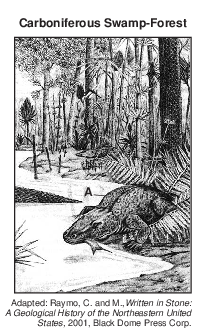
    Ordovician-age crinoid fossils of tropical marine origin are found in the bedrock of the HudsonMohawk lowlands region of New York State. This provides evidence that New York State was once located at a

    (1) lower latitude and lower elevation

    (2) lower latitude and higher elevation

    (3) higher latitude and lower elevation

    (4) higher latitude and higher elevation

    7

    The map below shows the inferred shape of the North American landmass in the past. The location of Florida is labeled.

    geologic-history, reference-tables, dynamic-earth, global-changes-resulted-from-plate-motions, earth-history, changes-resulted-from-plates-motion, standard-1-math-and-science-inquery, changing-length-of-a-shadow-based-on-the-motion-of-the-sun, standard-6-interconnectedness, models fig: esci82016-examw_g1.png

    Which event was occurring on Earth when Florida was located at the equator?

    (1) The dome-like uplift of the Adirondack region began.

    (2) The earliest dinosaurs appeared on Earth.

    (3) Oceanic oxygen began to enter the atmosphere.

    (4) Earth’s first coral reefs were forming.

    8

    Labeled lines on the map below show the inferred location of Earth’s equator during the middle of several geologic periods.

    geologic-history, reference-tables, dynamic-earth, global-changes-resulted-from-plate-motions, earth-history, changes-resulted-from-plates-motion, standard-1-math-and-science-inquery, changing-length-of-a-shadow-based-on-the-motion-of-the-sun, standard-6-interconnectedness, models fig: esci82017-examw_g25.png

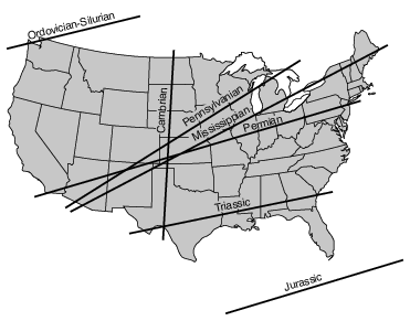
    Approximately how many million years ago (mya) was the region around current-day Watertown, New York, located the nearest to the equator?

    (1) 270 mya

    (2) 300 mya

    (3) 340 mya

    (4) 450 mya

    9

    Which block diagram represents the plate motion that causes the earthquakes that occur along the San Andreas Fault in California?

    reference-tables, tectonic-plates, dynamic-earth, global-changes-resulted-from-plate-motions, earth-history, changes-resulted-from-plates-motion, standard-1-math-and-science-inquery, changing-length-of-a-shadow-based-on-the-motion-of-the-sun, standard-6-interconnectedness, models fig: esci62016-examw_g25.png

    (1) reference-tables, tectonic-plates, dynamic-earth, global-changes-resulted-from-plate-motions, earth-history, changes-resulted-from-plates-motion, standard-1-math-and-science-inquery, changing-length-of-a-shadow-based-on-the-motion-of-the-sun, standard-6-interconnectedness, models fig: esci62016-examw_g26.png

    (2) reference-tables, tectonic-plates, dynamic-earth, global-changes-resulted-from-plate-motions, earth-history, changes-resulted-from-plates-motion, standard-1-math-and-science-inquery, changing-length-of-a-shadow-based-on-the-motion-of-the-sun, standard-6-interconnectedness, models fig: esci62016-examw_g27.png

    (3) reference-tables, tectonic-plates, dynamic-earth, global-changes-resulted-from-plate-motions, earth-history, changes-resulted-from-plates-motion, standard-1-math-and-science-inquery, changing-length-of-a-shadow-based-on-the-motion-of-the-sun, standard-6-interconnectedness, models fig: esci62016-examw_g28.png

    (4) reference-tables, tectonic-plates, dynamic-earth, global-changes-resulted-from-plate-motions, earth-history, changes-resulted-from-plates-motion, standard-1-math-and-science-inquery, changing-length-of-a-shadow-based-on-the-motion-of-the-sun, standard-6-interconnectedness, models fig: esci62016-examw_g29.png

    10

    The Hawaiian Islands were formed as a result of

    (1) lava flowing over Earth’s surface where two tectonic plates move apart

    (2) an oceanic plate moving over a mantle hot spot

    (3) two oceanic plates colliding to form an island arc

    (4) tectonic plates sliding past each other

    Base your answers to questions 11 on the timeline in image provided and on your knowledge of Earth science. The timeline represents the last 600 million years of geologic time. Shaded area A represents the Neogene Period.
    11

    Identify the name of one New York State landscape region where the index fossil Phacops may be found in the surface bedrock. [1]

    Allow 1 credit. Acceptable responses include:

    • — Allegheny Plateau/Appalachian Plateau (Uplands)

    • — The Catskills

    • — Hudson-Mohawk Lowlands

    • — Erie-Ontario Lowlands/Interior Lowlands

    Base your answers to questions 12 on the passage below.

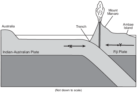
    Mount Manaro Erupts!

    Mount Manaro is a volcano on Ambae Island, about 1400 miles northeast of Australia. Ambae Island is located in the South Pacific Ocean at 15° south latitude, 168° east longitude.

    After Mount Manaro had erupted in 1995, Ambae Island residents developed an evacuation plan. When Mount Manaro began erupting gas, steam, and ash on November 27, 2005, scientists and residents watched the volcano carefully.

    The eruption became more severe on December 9, 2005, when steam and gases rose 1.8 miles up into the air. Rocks and ash began to fall on nearby farms and homes. Thousands of people left their homes, making it the largest evacuation ever on Ambae Island.

    12

    On the diagram in the image provided, draw one arrow through point X and one arrow through point Y to indicate the direction of tectonic plate motion near Mount Manaro. [1]

    dynamic-earth, global-changes-resulted-from-plate-motions, earth-history, changes-resulted-from-plates-motion, standard-6-interconnectedness, models fig: esci62012-ansb_w_abkq8.png

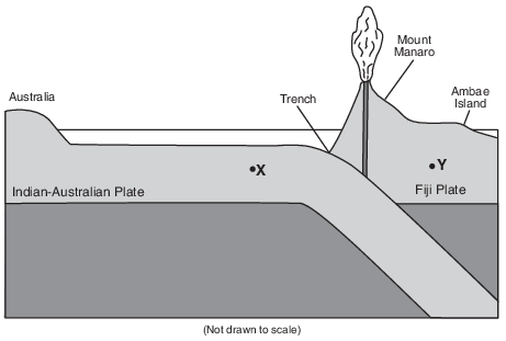
    Allow 1 credit if both arrows show the correct directions, even if the arrows do not pass through the dots.

    • Example of a 1-credit response:

    dynamic-earth, global-changes-resulted-from-plate-motions, earth-history, changes-resulted-from-plates-motion, standard-6-interconnectedness, models fig: esci62012-rg_g12.png